25 years ago: Earthquake in Ebreichsdorf (Lower Austria)
On July 11, 2000, at 04:49:49 Central European Summer Time (CEST), 3 km south of Ebreichsdorf in the Vienna Basin, approximately 30 km south of the city center of Vienna, the strongest earthquake since 1972 (Seebenstein) occurred. The magnitude was 4.8 on the Richter scale. More than 1000 reports were received by the Austrian Seismological Service, enabling a detailed macroseismic analysis.
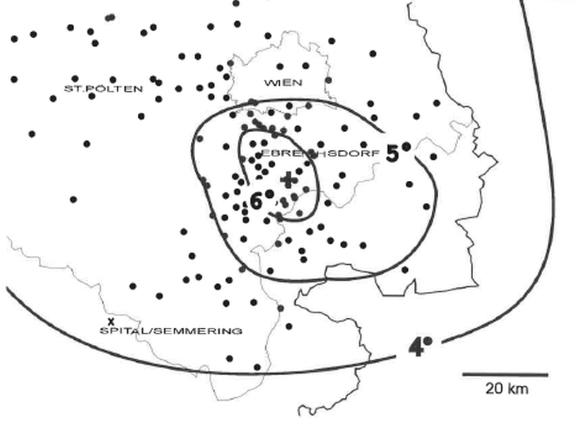
The results of the analysis are presented in an isosurface map showing the effects of the earthquake. The entire area in which the tremors can be felt is referred to as the shaking area.
Isoseisten_600.jpg
Seismic intensity isosurface map for the earthquake on July 11, 2000: The lines indicate areas of similar effects, the strength of which is expressed in degrees of intensity. The dots show those locations in Austria from which the perceptibility is known. © GeoSphere Austria/Meurers.
The epicentral intensity reached slightly more than VI degrees on the twelve-level European Macroseismic Scale (EMS-98). The tremors were clearly felt in large parts of eastern Austria and also in Vienna. There was considerable damage to buildings at the epicenter in Ebreichsdorf and the surrounding area. The elementary school in Trumau was closed due to the risk of collapse and most of the ceilings had to be replaced. Severe damage was also reported in towns further away, such as Eisenstadt, Traiskirchen and Gumpoldskirchen. There were large cracks in walls and damaged chimneys.
The earthquake activity in the southern Vienna Basin can be traced back to the horizontal displacement along the Mur-Mürztal fault, which causes the eastern part of the crust to be pushed eastwards. This movement created the Vienna Basin, which is crossed by a deep fault where Ebreichsdorf is located. It extends from Seebenstein (earthquake in 1972) via Wiener Neustadt (strong earthquakes in 1668, 1712, 1841), Ebreichsdorf (earthquakes in 1938, 2000, 2013) and Schwadorf (damaging earthquake in 1927) and continues north of the Danube towards Slovakia (earthquake near Dobra Voda, 1904).
As historical earthquake research has shown, Ebreichsdorf has repeatedly been the scene of strong earthquakes over the past centuries. The first quake that caused documented damage occurred in 1590 with a reconstructed magnitude of 3.9. The strongest and most serious quake ever measured in Ebreichsdorf took place in 1938. It had a magnitude of 5.0. At that time, almost all houses in the area of the epicenter suffered damage to the masonry, with some cracks being centimetres wide. Chimneys were damaged, ballustrades and factory chimneys collapsed in Baden and in the 10th district of Vienna.
Ebreichsdorf is located in a zone with a relatively high earthquake risk, comparable to that in the Mürztal valley in Styria or in the Innsbruck area. This fact is taken into account in ÖNORM EN 1998-1 on earthquake-adapted construction methods. See also www.oge.or.at.
The main earthquake was followed by a strong aftershock with a magnitude of 4.5 at 12:56 CEST. Since the events in July 2000, two further earthquakes with an intensity greater than or equal to V have occurred. On September 20, 2013, at 4:06 a.m. CEST, an earthquake with a magnitude of 4.3 occurred in the Ebreichsdorf area. This earthquake was also clearly felt not only in Lower Austria, but also in Burgenland and Vienna. This was followed 12 days later on October 2, 2013 at 19:17 CEST by an earthquake of approximately the same magnitude with an epicenter near Ebreichsdorf, which was also felt strongly and reported to the earthquake service by more than 3,000 people. In both cases, the epicentral intensity reached V to VI degrees on the twelve-part European Macroseismic Scale (EMS-98). A total of seven earthquakes with magnitudes between 3 and 4.5 were recorded in the region between 2000 and today.
In contrast to magnitude, which is determined from measurements, the intensity of an earthquake is location-dependent and is usually determined from earthquake perception reports. The intensity data points obtained in this way are then displayed on a map, from which the shaking area and the extent of the local effects - e.g. the damage area - can be derived. Typically, intensities are represented as Roman numerals from I (not felt) to XII (total destruction) according to the EMS-98 Scale.
As already mentioned, earthquake intensity is determined from reports of the population's perceptions and historical records of earthquake damage. Before there were seismometers, these were the only sources of information about past earthquakes. From the intensity distribution, conclusions can be drawn about the depth of the earthquake and the seismic energy released during the earthquake, without the aid of instruments. This is why macroseismic earthquake analysis is particularly important for historical earthquakes, provided that the effects of these earthquakes are well described in the records.