40 years since the Chernobyl nuclear disaster
On 26 April 1986, the Chernobyl nuclear power plant (then in the Soviet Union, now in Ukraine) suffered the worst nuclear accident in history to date. The radioactive cloud reached Austria after around 80 hours. In those areas where it rained, significant amounts of caesium and other radionuclides were deposited. The provinces of Salzburg, Upper Austria, Styria and Carinthia were particularly affected. Among other things, the Chernobyl disaster led to the establishment of a dense, semi-automated monitoring network in Austria and to regularly practised civil protection emergency plans, for which GeoSphere Austria develops and operates atmospheric transport models.
At 1.23 am local time, reactor unit 4 at the Chernobyl nuclear power station exploded, not far from the city of Pripyat, which had a population of 50,000 and was one of the most modern cities in the Soviet Union at the time. In the hours that followed, a radioactive cloud was carried by strong southerly winds first towards Scandinavia and then, with an easterly wind, towards Central Europe. It was precisely at this moment that it began to rain in western Austria. On 29 April, daily maximum rainfall of 20 millimetres was recorded in the Pongau and Lungau regions. The following day, rainfall reached up to 25 millimetres in the Hausruck and Traunviertel regions, and 20 millimetres in the Flachgau region. In eastern Austria, however, there was little to no rain. As a result, due to the long half-life of caesium-137 (30 years), significant levels of contamination can still be found today in mushrooms and game in the affected areas.
The nuclear disaster led to the establishment of the highly dense, semi-automated weather monitoring network TAWES, which now comprises around 270 weather stations across Austria. The aim was to obtain highly detailed information on near-surface winds and precipitation, so as to be able to quickly assess the direction of the radioactive cloud’s movement in the event of an accident at a nuclear power plant near the border. ‘In combination with the INCA nowcasting model, highly accurate situation analyses can now be passed on to the authorities,’ says Gerhard Wotawa of GeoSphere Austria, which forms part of Austria’s crisis and disaster management system. In regular exercises, the movement of a fictitious radioactive cloud is calculated and the entire process of communicating the results to government agencies is simulated. ‘Following accidents involving hazardous substances, the most important factors are the concentration of pollutants present and how much of it reaches the ground via rain or snowfall,’ explains Wotawa.
Today, GeoSphere operates dispersion models for a range of requirements on different scales. These include a large-scale meteorological-chemical forecasting model that provides rapid and highly accurate information for crisis and disaster management in the event of accidents at nuclear power stations, as well as following volcanic eruptions. For example, following the nuclear accident in Fukushima (JPN) on 11 March 2011, GeoSphere (then still known as ZAMG – Central Institute for Meteorology and Geodynamics) calculated the large-scale dispersion of the radioactive cloud. Combined with data from the Comprehensive Nuclear-Test-Ban Treaty Organisation (CTBTO) in Vienna, this led to the first realistic estimate of the radioactive source strength.
Another specialist application involves accidents involving toxic substances in cities. In this area, GeoSphere has been working with the Vienna Fire Service, amongst others, for many years. As a result, the Vienna Fire Service’s hazardous materials unit now has access to computer model calculations, chemical databases and real-time meteorological information in its emergency vehicles, enabling it to make a rapid and well-founded initial assessment.
In the hours following the Chernobyl nuclear accident, it rained mainly in Salzburg and Upper Austria, but also in parts of Carinthia and Styria.
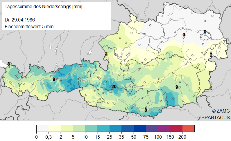
Tschernobyl_precipitation_29-04-1986.png
Daily rainfall total [mm] on 29 April 1986 for Austria. © GeoSphere Austria.
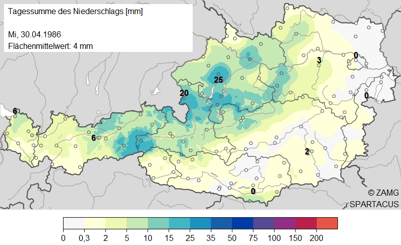
Tschernobyl_precipitation_30-04-1986.png
Daily rainfall total [mm] on 30 April 1986 for Austria. © GeoSphere Austria.
Translated with DeepL.com (free version)