Driest period in Austria in 176 years of recorded history
climate, meteorology
Driest period in Austria in 176 years of recorded history
It is not just this year’s summer, with its two heatwaves featuring extreme temperatures of up to 41.2 degrees, that is currently causing unprecedented drought in Austria. Precipitation deficits have been at record levels for a year now. At some monitoring stations in the east of the country, it has not rained at all for weeks – and there is no sign of the situation easing any time soon.
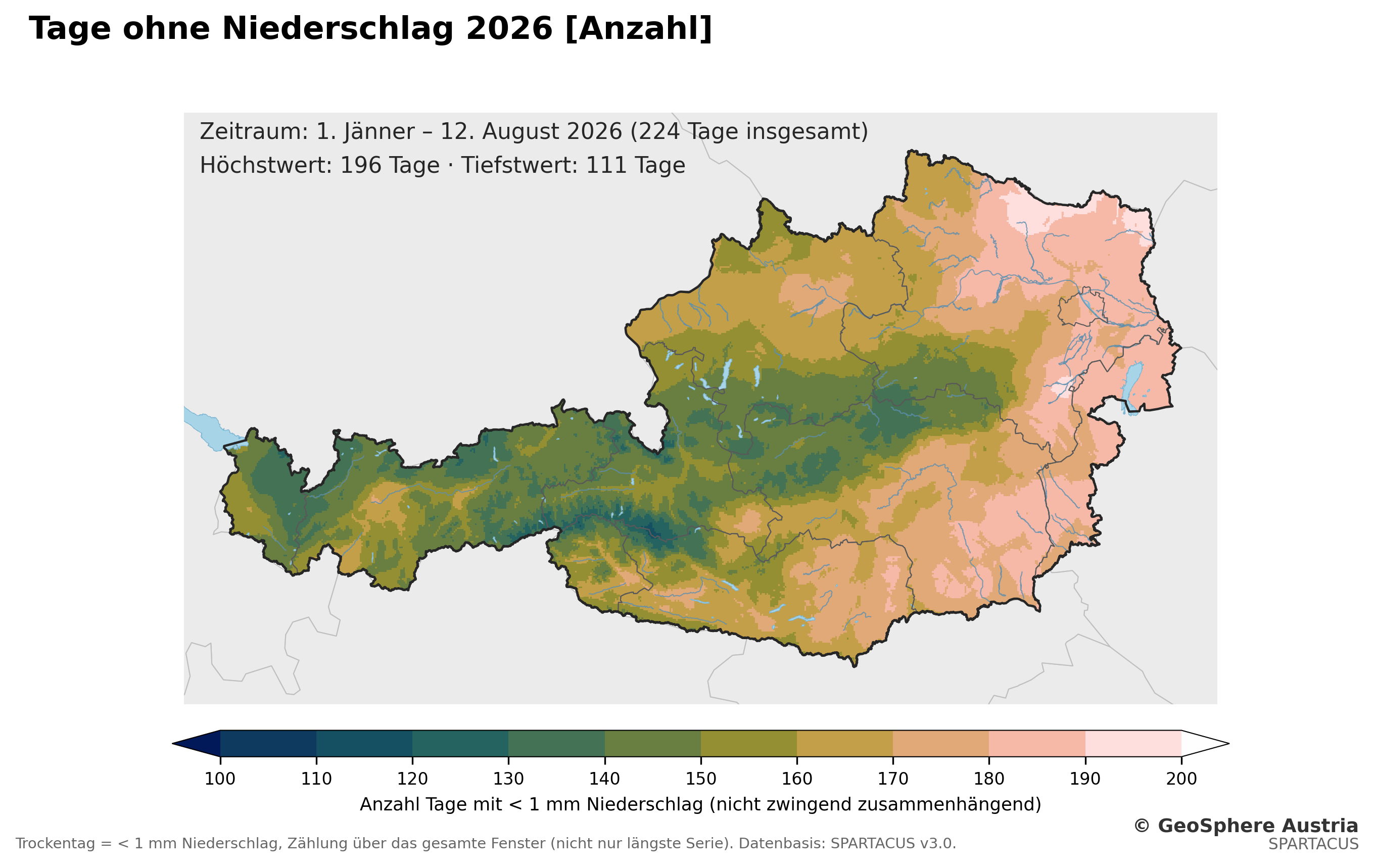
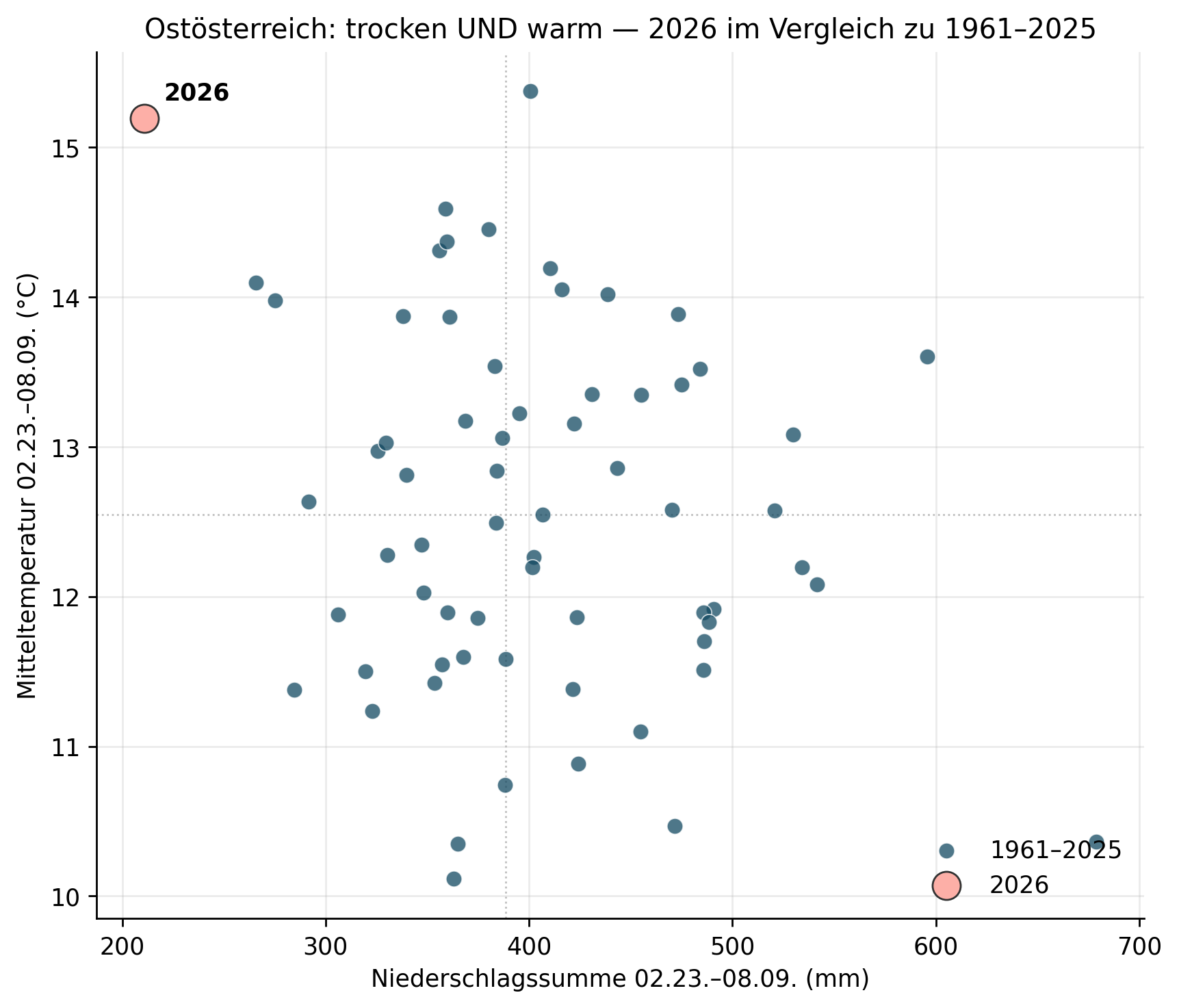
‘The past twelve months will go down in history as the driest since records began in 1850,’ sums up climate researcher Klaus Haslinger from GeoSphere Austria. The data reported by the monitoring stations also speaks for itself: Between 1 January and 12 August 2026, 72 per cent of Austria’s land area experienced more dry days than in any of the previous 65 years. ‘Since 23 February 2026, there has been an almost continuous precipitation deficit in Vienna, Lower Austria and Burgenland,’ adds climatologist Peter Müller. Between 23 February and 9 August, only 210.9 millimetres of rainfall fell, compared with the usual 405 millimetres. ‘This is the driest comparable period since at least 1961.’ The previous record lows from 2003 (265.8 mm) and 2015 (275 mm) are significantly higher.
At present, there is no sign that this period of extreme drought will ease. ‘Even average rainfall would not be enough to make up for the current rainfall deficit so quickly,’ explains Klaus Haslinger. ‘From October onwards, long-range forecasts suggest slightly wetter weather; however, forecasts in the Alpine region are generally very uncertain when they extend beyond a one-month forecast horizon.’ GeoSphere Austria is in regular contact with decision-makers in Austria regarding the current situation and the possible impacts of this exceptional period of drought. Updated data and analyses are provided on an ongoing basis to support science-based decision-making.
Variations in rainfall deficits
The longest continuous dry spell in 2026 (consecutive days with less than one millimetre of rainfall) lasted up to 48 days nationwide – although this occurred in the spring. At present, the east is particularly affected: in Poysdorf in the northern Weinviertel, for example, it has not rained at all since 8 July. At the GeoSphere measuring station at Wiener Neustadt Airport, the record dates back to 1857. The period from February to July 2026 was the driest there since records began 169 years ago, with 170 millimetres of rainfall. In Krems, where measurements have been taken since 1867, a new record low of 177 millimetres was recorded. The same applies to Stift Zwettl (since 1883) with 190 millimetres, Retz (since 1895) with 115 millimetres, and Waidhofen/Ybbs (since 1896) with 362 millimetres.
Varying from province to province
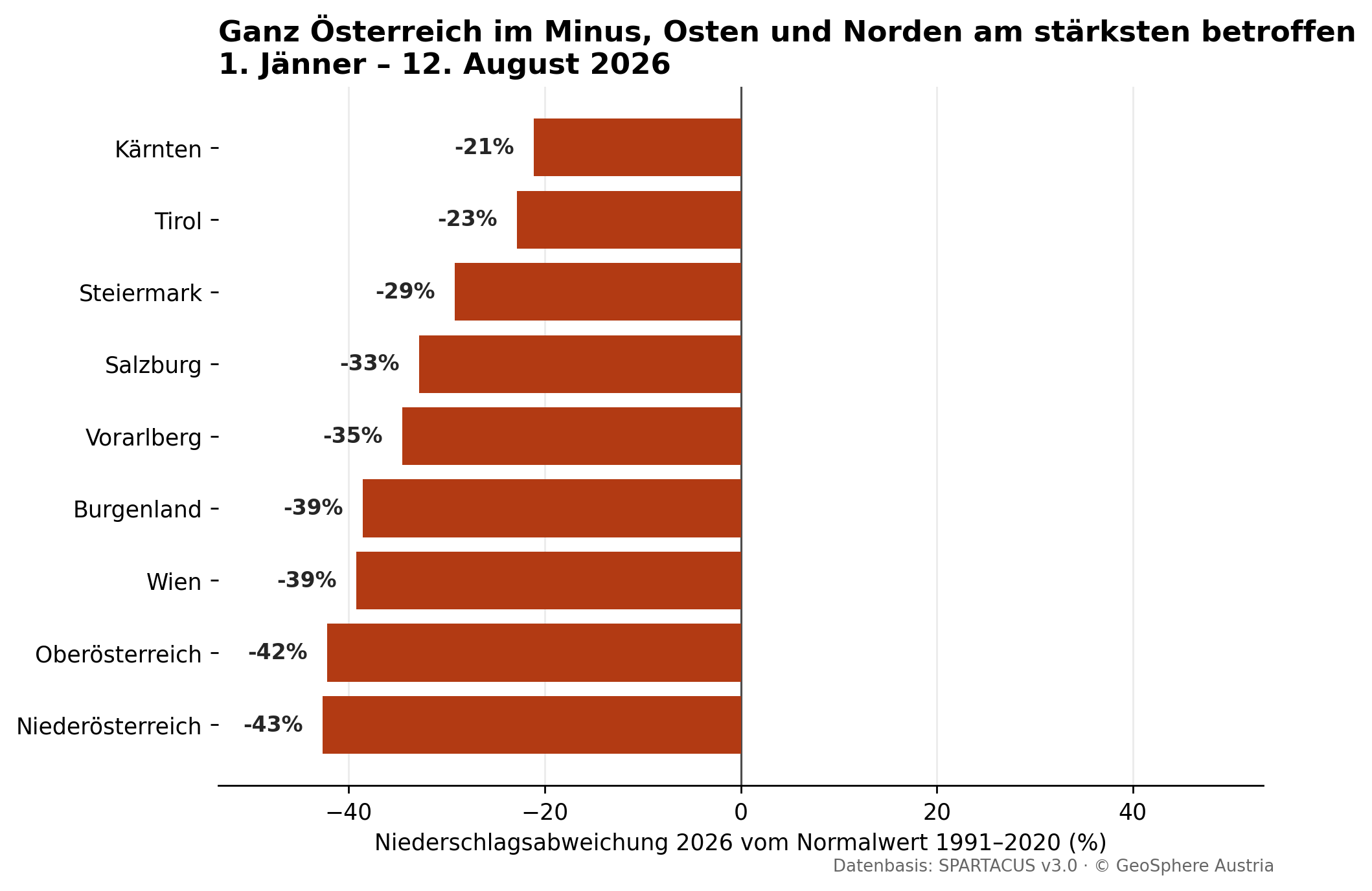
There has been too little rain throughout Austria, but there are differences: In Carinthia, the rainfall deficit (1 January to 12 August) stands at minus 21 per cent; in Tyrol at minus 23 per cent; in Styria at minus 29 per cent; in Salzburg at minus 33 per cent; in Vorarlberg at minus 35 per cent; in Burgenland at minus 39 per cent; in Vienna at minus 39 per cent, in Upper Austria at minus 42 per cent and in Lower Austria at minus 43 per cent.
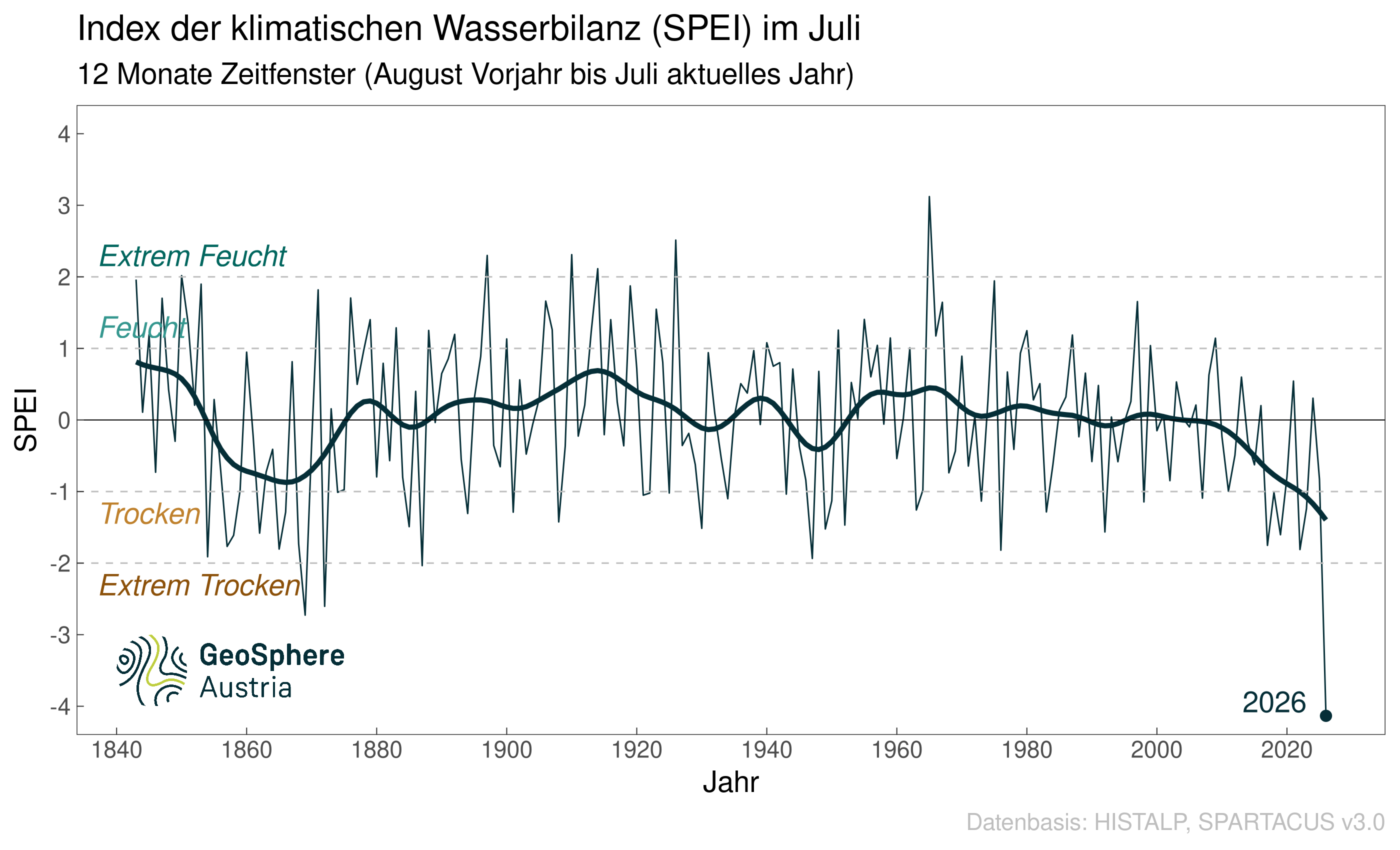
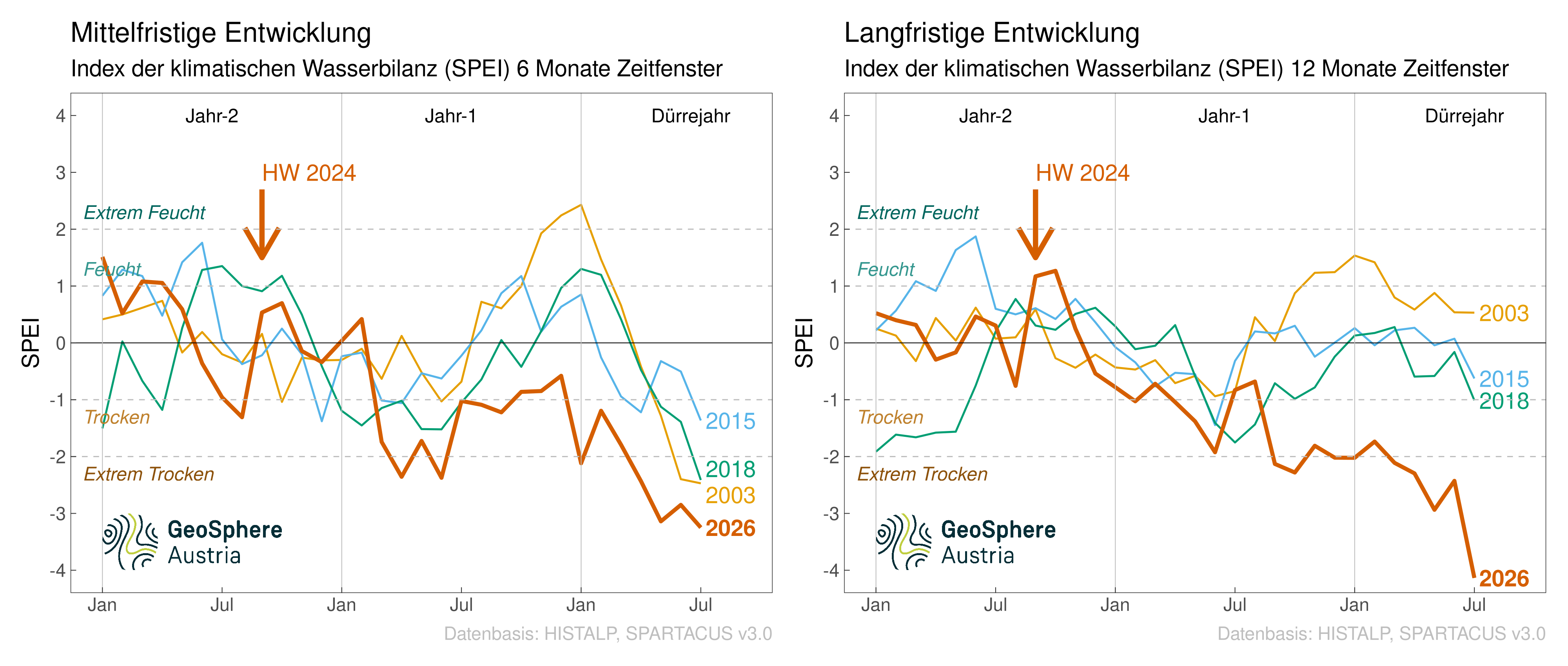
Alongside the drought, it was also exceptionally hot: between 23 February and 9 August, an average of 26 hot days (at least 30 degrees) were recorded across eastern Austria – also a record since at least 1961. The previous record was 22 days in 2015. ‘However, precipitation is only one factor that governs the water balance; the second is evaporation,’ emphasises climate researcher Haslinger. ‘The warmer the atmosphere, the more moisture it can draw from the ground. This is referred to as potential evaporation, or the ‘thirst of the atmosphere’.’ The climatic water balance (‘Standardised Precipitation Evapotranspiration Index – SPEI’), which expresses the difference between precipitation and potential evaporation, has therefore become the established measure for monitoring drought. SPEI values between minus 1 and plus 1 indicate normal conditions; values below minus 1 indicate dry conditions, and those below minus 2 indicate extreme drought. ‘In July 2026, the SPEI for the past twelve months fell below minus 4. This is unprecedented in the entire history of measurements and thus eclipses even previous extreme years,’ says Haslinger. The reasons for this are the precipitation deficit that has built up over the past two years due to increased high-pressure weather systems, and the rise in evaporation caused by higher temperatures.
If one compares the temporal progression of the current drought event with similar ones in 2003, 2015 and 2018, an analysis of the SPEI over a medium-term timescale (six months) reveals a sharp decline each time from the start of the ‘drought year’, which points to a very dry spring. In 2026, conditions were already dry at the start of the year, and the situation worsened over the course of spring and summer. On a long-term timescale (twelve months), the years 2003, 2015 and 2018 were within the normal range or even wet at the start of the ‘drought year’. In contrast, at the start of this year, the SPEI was already on the verge of the extremely dry range. ‘A condition that has been building up progressively since the floods of 2024. The further consequence of the very dry spring and summer, including heatwaves, is the historic low recorded as of July 2026,’ summarises climate researcher Klaus Haslinger.