Autumn 2025 slightly too mild
Preliminary climate assessment by GeoSphere Austria: Temperatures in the meteorological autumn of 2025 were slightly above the long-term average (among the 50 warmest in recorded history). Precipitation (-10 per cent) and hours of sunshine (-3 per cent) averaged across Austria were within the climate norm.
The meteorological autumn (September, October, November) brought the temperature fluctuations typical for the season and was slightly too mild overall.
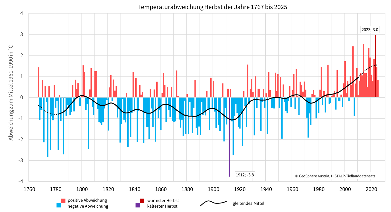
‘In the preliminary assessment, the meteorological autumn of 2025 ranks 43rd in the series of warmest autumns in 259 years of measurement history in the lowlands of Austria and 39th in the 175-year mountain measurement series,’ says climatologist Alexander Orlik from GeoSphere Austria.
Compared to the recent past, the climate average for 1991-2020, autumn 2025 in the lowlands and mountains of Austria was 0.1 degrees above average. Compared to the period 1961-1990, which was not yet so strongly influenced by global warming, autumn 2025 is 0.8 degrees too mild in the lowlands of Austria and 0.5 degrees too mild in the mountains.
Temperature_comparison_autum2025_1961-1990.png
Autumn in comparison since 1767: The figure shows above-average warm (red) and cold (blue) autumns since 1767 in comparison to the climate reference period 1961-1990, based on GeoSphere Austria HISTALP lowland data. The smoothed trend line is shown in black. © GeoSphere Austria.
In mid-September and early November, there was a period of unusually warm weather. At some weather stations, temperatures were even close to monthly records. For example, on 19 September, 16.0 °C was measured at the Pitztal Glacier (T, 2864 m) and 13.6 °C at Brunnenkogel (T, 3437 m). This is the second highest value measured in September at both stations. However, both stations have relatively short measurement series (Pitztal Glacier since 1989 and Brunnenkogel since 2003).
The number of days with frost (minimum temperature below 0 °C) in autumn 2025 was approximately within the long-term average at all altitudes: Below 500 metres above sea level, there were 10 days of frost on average across Austria (+1 per cent above the 1991-2020 average), between 500 and 1000 metres above sea level there were 18 days of frost (+6 per cent above the average), between 1,000 and 1,500 metres above sea level there were 24 days of frost (-2 per cent compared to the average), and between 1,500 and 2,000 metres there were 30 days of frost (+0 per cent compared to the average).
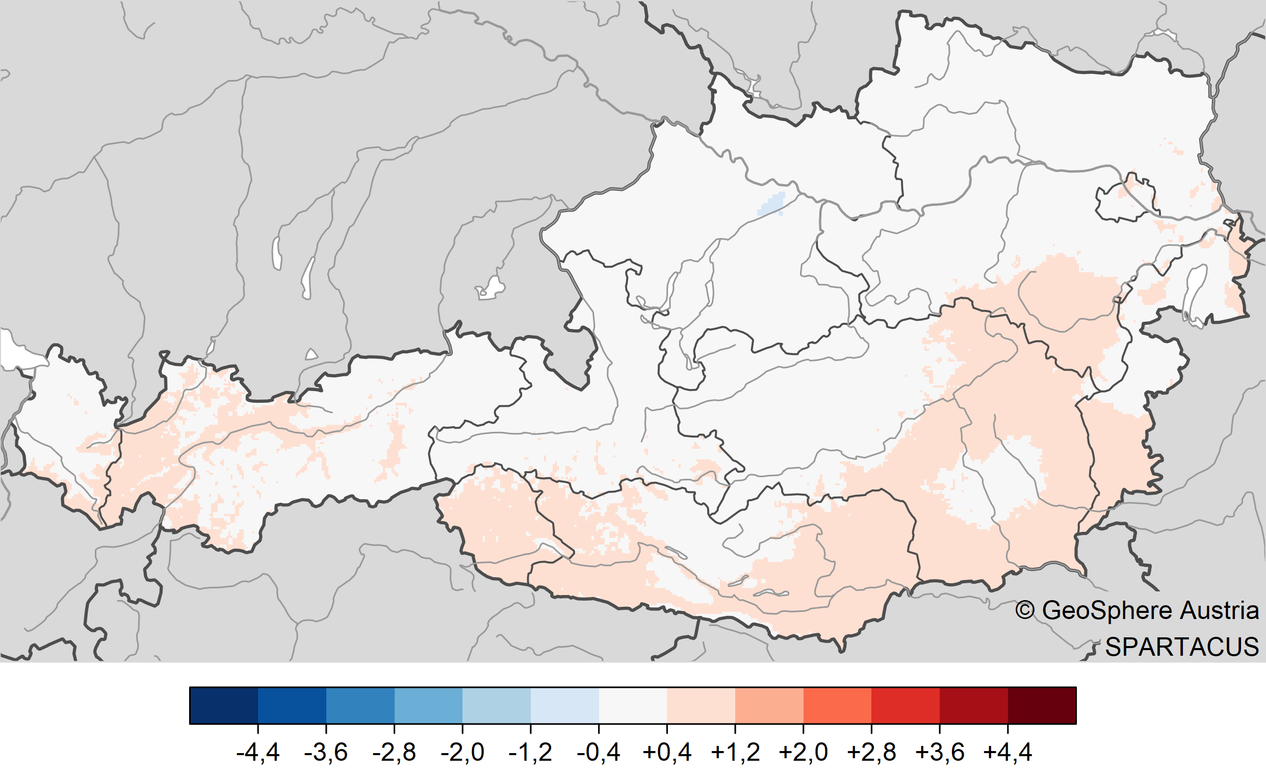
temperature_autumn2025.png
Temperature in autumn 2025: deviation of temperature from the mean. Bottom image compared to the 1961-1990 mean, top image compared to the 1991-2020 mean. Evaluation with SPARTACUS data up to and including 27 November 2025. © GeoSphere Austria.
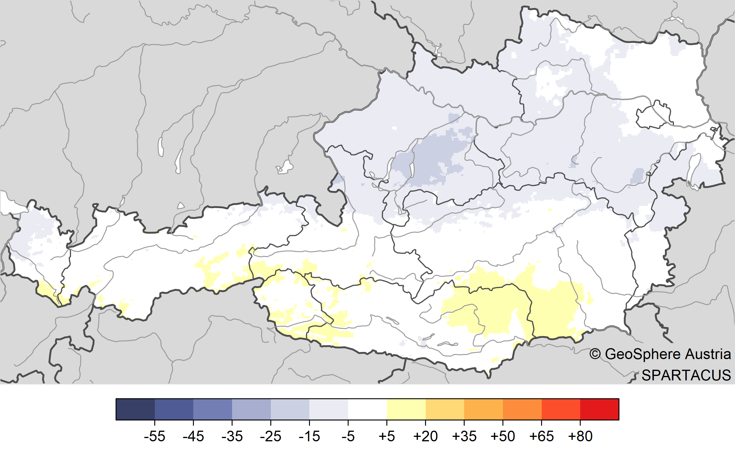
‘Precipitation levels in Austria during the meteorological autumn of 2025 were 10 per cent below the long-term average. This is well within the normal range of variation,’ says Alexander Orlik from GeoSphere Austria, ‘the typical deviations in precipitation levels in autumn are plus/minus 21 per cent.’
The regional analysis reveals significant differences. ‘Roughly speaking, there is a gradient from a too dry south-west to a too wet north-east,’ says climatologist Orlik. "For example, parts of East Tyrol and Upper Carinthia had 25 to 50 per cent less precipitation than in an average autumn. In the Waldviertel and Weinviertel regions, especially in the northern areas, there was up to 40 per cent more precipitation than the long-term average.
Autumn 2025 brought the first signs of winter typical for the season. At the end of November, snow depths below 1,500 metres above sea level are now roughly in line with the climatological average. Above 1,500 metres above sea level, snow depths are currently up to about 40 per cent below average.
For example, at the end of November (as of 28 November 2025), there was up to 77 centimetres of snow at the Rudolfshütte weather station in the Hohe Tauern (S, 2317 metres). The long-term average here at the end of November is up to 114 centimetres (-32 per cent). In Obergurgl (T, 1941 metres), there are currently 28 centimetres compared to 40 centimetres on average over many years (-30 per cent).

precipitation_autumn2025.png
Precipitation in autumn 2025: deviation of precipitation from the average: bottom image compared to the 1961-1990 average, top image compared to the 1991-2020 average. Evaluation with SPARTACUS data up to and including 27 November 2025. © GeoSphere Austria.
sunshine_autumn2025.png
Sunshine duration in autumn 2025: Deviation in sunshine duration: bottom image compared to the 1961–1990 average, top image compared to the 1991–2020 average. Analysis using SPARTACUS data up to and including 27 November 2025. © GeoSphere Austria.
Translated with DeepL.com (free version)