Average earthquake year
In 2025, around 9,600 seismic events were recorded worldwide by the station network of the GeoSphere Austria earthquake service. 1,100 earthquakes were located in Austria, 61 of which were felt by the population. In addition, seven earthquakes from neighbouring countries were felt in Austria in 2025.
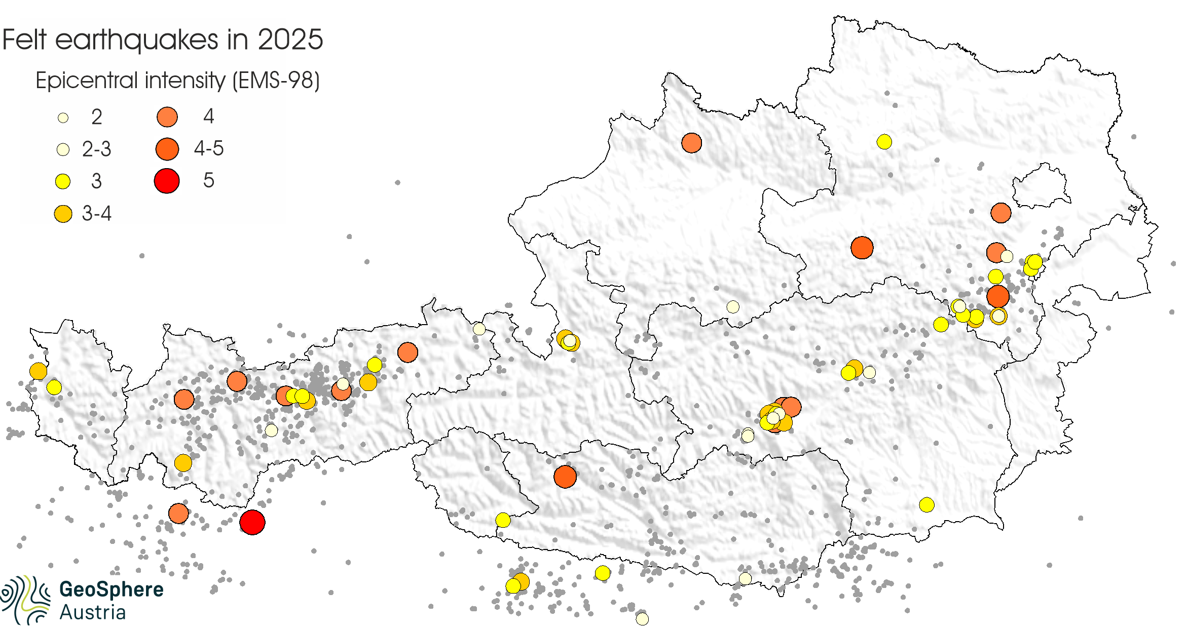
‘In 2025, a total of 68 earthquakes were felt by the population in Austria,’ says seismologist Rita Meurers from GeoSphere Austria, ‘This figure is slightly below the average of 78 earthquakes per year over the past ten years. With the exception of a few hairline cracks and minor plaster damage, earthquakes in Austria in 2025 did not cause any damage to buildings.’
The two strongest events of the year each had a magnitude of 3.2 and were recorded in Lower Austria in the Mostviertel region near Scheibbs and in the southern Vienna Basin near Neunkirchen.
earthquakes_report_2025.png
Earthquakes 2025: Epicentral intensity (maximum strength of perceptibility) of earthquakes felt by the population. For earthquakes with epicentres abroad (except South Tyrol), the maximum intensity reached in Austria is given. In addition, the grey dots mark the earthquakes recorded by instruments. © GeoSphere Austria.
At 1,100, the number of instrumentally recorded earthquakes in Austria in 2025 was also slightly below the average for previous years.
The continuous expansion of the station network and cooperation and data exchange with national and international institutions are of great importance to the Austrian Earthquake Service of GeoSphere Austria in order to ensure optimal seismic monitoring of the entire federal territory.
felt_earthquakes_2000-2025_Gridlines.png
Felt earthquakes in Austria since 2000: On average, there were 58 felt earthquakes per year in Austria between 2000 and 2025. In the ten years from 2016 to 2025, there were an average of 78 per year. © GeoSphere Austria.
The number of earthquakes felt in Styria in 2025 was relatively high at 18. More than half of these earthquakes occurred in the area between Unzmarkt and Judenburg. Lower Austria came in second place in 2025 with 17 earthquakes felt, most of them in the southern Vienna Basin and the Semmering area. In Tyrol, there were 14 noticeable earthquakes in 2025, significantly fewer than in previous years. The strongest were located in Wörgl and Pfunds, each with a magnitude of 3.0. In the ranking of federal states, Salzburg follows with five, Carinthia with three and Upper Austria and Vorarlberg with two perceptible earthquakes each. In 2025, seven earthquakes were felt in Austria from neighbouring countries, with epicentres in Italy, Slovenia and Croatia.
In 2025, around 1,600 perception reports were submitted to the Austrian Earthquake Service of GeoSphere Austria via the online perception form and the ‘QuakeWatch Austria’ app (->report earthquake). Most reports (264) were sent in response to the earthquake in Wörgl on 13 February 2025.
The information provided by the public gives an indication of the strength of the tremors and enables the degree of intensity to be determined on the European Macroseismic Scale EMS-98 (see below). It also makes a significant contribution to determining the earthquake risk in Austria. The Austrian Earthquake Service would like to thank the public for the numerous reports.
Magnitude is a measure of the energy released at the earthquake's epicentre. It is determined from instrumental recordings (seismograms). The determination of magnitude is independent of damage and perceptibility and was developed by the American geophysicist Charles Richter.
Intensity describes the effects of an earthquake on the Earth's surface. Most countries in Europe, including Austria, use the 12-point European Macroseismic Scale 1998 (EMS-98) to determine intensity.
On 13 February at 11:43 CET, an earthquake measuring 3.0 on the Richter scale struck Wörgl, Tyrol (47.49°N, 12.08°E). It was clearly felt by many people within a radius of around 12 kilometres. The tremors were felt sporadically as far away as Innsbruck, Kössen and Jochberg. A total of 264 reports of the tremors were sent in by the public, most of them from Wörgl, Langkampfen, Kufstein and Kirchbichl. The tremors were described as distinct, unsettling and, in some cases, frightening. Buildings shook slightly to significantly, and objects and liquids moved. The quake occurred at a relatively large focal depth of 11 kilometres. The intensity in the towns around the epicentre was 4 on the 12-point European Macroseismic Scale (EMS-98).
Numerous people were awakened from their sleep at 01:47 CEST on 2 May by a strong earthquake measuring 3.2 on the Richter scale. The epicentre was located approximately 6 kilometres south of Scheibbs, Lower Austria (47.96°N, 15.15°E). Many people were startled and observed significant shaking of buildings, furniture and objects. The epicentral intensity was 4 to 5 degrees on the EMS-98 scale. It was the strongest earthquake in the Scheibbs area since the historic earthquake in 1876, which caused major damage to numerous buildings.
A few kilometres southwest of Berndorf, Lower Austria (47.92°N, 16.06°E), the earth shook at 13:13 CEST on 13 July with a magnitude of 3.0. The tremors were clearly felt in some areas between Baden, Wiener Neustadt and Pernitz. Due to the relatively large focal depth of about 14 kilometres, the intensity was only just under 4 degrees (EMS-98).
On 5 August at 11:55 CEST, an earthquake with a magnitude of 3.0 occurred about 4 kilometres east of Pfunds, Tyrol (46.96°N, 10.60°E). The earthquake was felt by the population in the Upper Inn Valley between Prutz and Nauders as a weak to distinct tremor and rumbling. Screens shook and liquids in glasses moved. The earthquake was also felt outdoors in some cases. The epicentral intensity reached 3 to 4 degrees on the EMS-98 scale.
One of the two strongest earthquakes of the year occurred on 20 October at 13:54 CEST with its epicentre approximately 2 kilometres west of Neunkirchen, Lower Austria (47.72°N, 16.06°E). The magnitude 3.2 quake was felt clearly to strongly by many people. Buildings shook, objects and liquids moved. More than 120 reports of the quake were sent to the earthquake service. In isolated cases, hairline cracks and small pieces of plaster falling off were reported. The epicentral intensity reached 4 to 5 degrees (EMS-98).
A strong earthquake occurred in the Mölltal valley in Carinthia on 29 October at 10:23 CET with its epicentre near Flattach (46.93°N, 13.13°E). With a magnitude of 3.0, the tremors were felt strongly in some places and described as similar to an explosion. Buildings shook noticeably, causing some people to panic and leave the building. The maximum intensity was 4 to 5 degrees on the EMS-98 scale.
Translated with DeepL.com (free version)