The 1976 Friuli Earthquake – 50 Years On: Lessons Learnt and Lasting Significance
6 May 2026 marks the 50th anniversary of the devastating earthquake in Friuli (north-eastern Italy). With a moment magnitude (Mw) of 6.5, it is regarded as the most devastating natural disaster in Italy in the second half of the 20th century and is thus one of the most destructive earthquakes in recent European history. To this day, it remains a key reference case for seismology, disaster prevention and risk management in the Alpine region.
On the evening of 6 May 1976, at 21:00 CET, a powerful earthquake shook the Friuli-Venezia Giulia region in north-eastern Italy for about one minute. The epicentre (46.25°N, 13.22°E) was located south-east of the town of Gemona del Friuli, where the effects were particularly severe. The epicentral intensity reached a value of I0=X on the 12-point European Macroseismic Scale (EMS-98). There was massive destruction in numerous towns and villages, including Gemona, Venzone and Osoppo. Many historic buildings were also destroyed; for example, a side aisle and the bell tower of the famous Cathedral of Santa Maria Assunta in Gemona collapsed. In addition to these severely affected areas in Italy, significant damage was also recorded in what is now Slovenia and in Austria.
Almost 1,000 people lost their lives (Tertulliani et al., 2018), more than 2,000 were injured, and around 150,000 lost their homes as a result of the earthquake (Drimmel et al., 1979). The seismic activity lasted for a very long time and numerous aftershocks were recorded, continuing into 1977. Two distinct main phases can be identified in the earthquake series, in May and September 1976.
About one minute before the mainshock, a strong foreshock of magnitude 4.5 (Ml) was recorded on 6 May 1976 (AEC, Austrian Earthquake Catalogue, GeoSphere Austria). The strongest aftershock occurred on 15 September 1976 with a magnitude of 6.1 Ml (AEC). This caused further severe damage to buildings, particularly in the epicentral area. This prolonged series was also clearly felt in Austria. A total of 84 earthquakes were felt in Austria, 81 of them by the end of 1976.
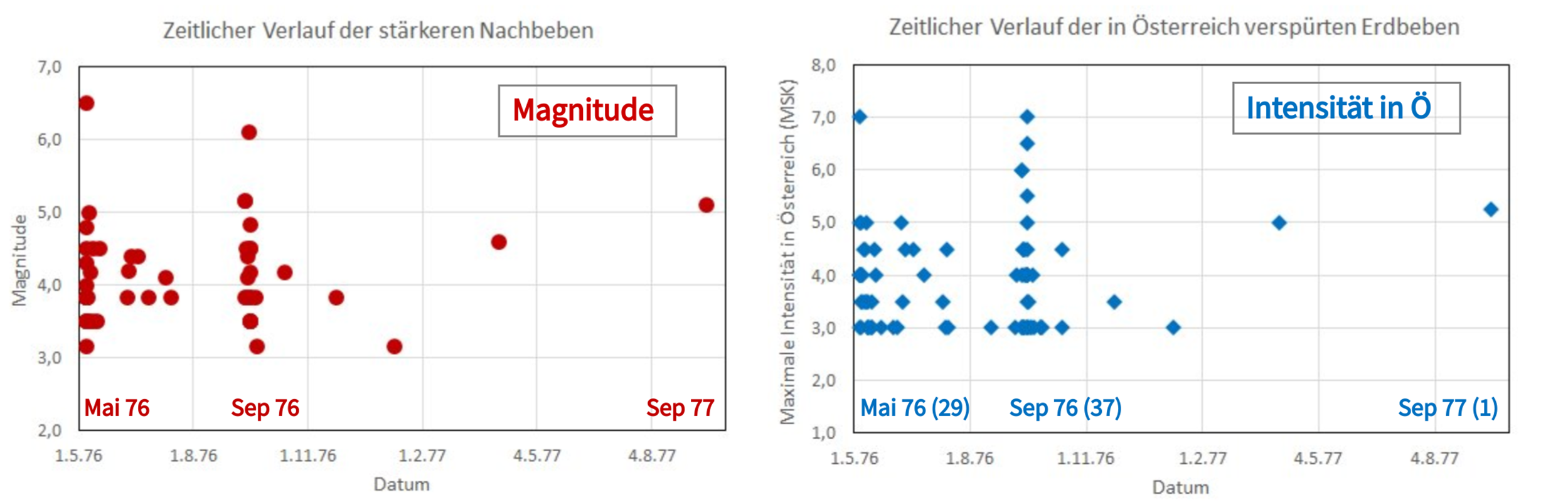
Friuli_sequence_earthquake.png
Chronological sequence of stronger aftershocks and earthquakes felt in Austria during the 1976/1977 Friuli earthquake series. © AEC, GeoSphere Austria.
From a scientific perspective, the Friuli earthquake ranks among the most significant events for understanding seismicity in the southern Alpine region. The tectonic cause of the earthquake can be attributed to a displacement of the Adriatic microplate towards the European continental plate at a speed of approximately 2 millimetres per year.
The instrumental records from that time are also of particular interest from today’s perspective. The ground movements caused by the earthquake were recorded over 300 kilometres away in Vienna on the Hohe Warte using the so-called Conrad pendulum, a seismometer developed by the first director of the Austrian Seismological Service, Victor Conrad (1876–1962).
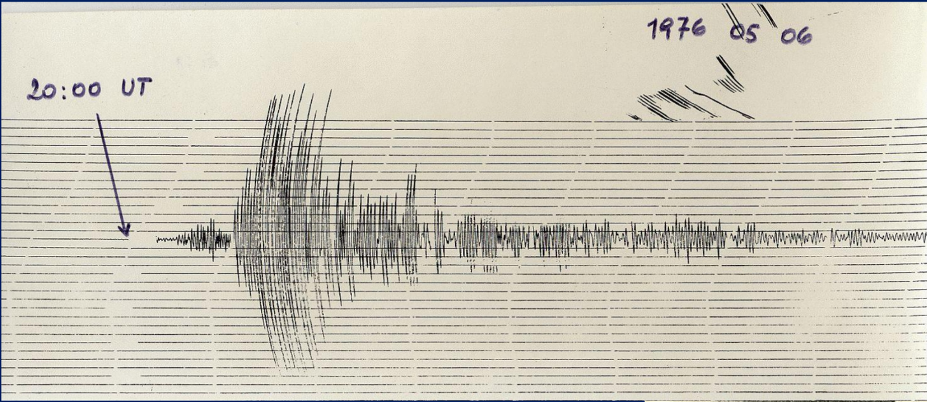
Friuli_recording.png
Recording with the Conrad pendulum at ZAMG (now GeoSphere Austria) on the Hohe Warte in Vienna. Epicentral distance 325 km, ~54 seconds to first response. © GeoSphere Austria.
The earthquake was also clearly felt in Austria. In total, reports were sent to the Austrian Seismological Service from more than 1,000 locations. In some towns in southern Carinthia, such as Kötschach-Mauthen, Dellach im Gailtal, Kirchbach, Rattendorf and Hermagor, there was significant damage to buildings and the intensity reached VII on the EMS-98 scale.
The effects were felt both in the infrastructure and in the daily lives of the population. In addition to extensive damage to buildings, rockfalls and power cuts occurred, particularly in Carinthia. Areas in the Gailtal valley were particularly affected, with damage documented in numerous locations. Reports include, among other things, significant cracks in walls, large pieces of plaster falling off, chimneys and roof tiles collapsing, as well as damage to churches, schools and residential buildings. Local infrastructure damage, such as a collapsed bridge, was also recorded. In total, 63 locations in Carinthia were recorded with intensities of at least VI (EMS-98).
A report on observations from the archives of the Austrian Seismological Service, compiled by the former Paternion Gendarmerie Post Command (Villach, Carinthia), provides a clear example of how the effects of the Friuli earthquake were documented in Austria. Such reports recorded tremors, damage and observations by the population in a timely manner and enabled the determination of seismic intensity using the EMS-98 scale.

Friuli_historical_observation_report.png
Historical observation report from the former Paternion Gendarmerie Post Command (Villach, Carinthia) from the archives of the Austrian Seismological Service. © GeoSphere Austria.
The systematic re-evaluation of these historical reports according to the EMS-98 scale later enabled the intensity distribution of the event to be reconstructed in detail as part of a Europe-wide study. The map shows that the quake was felt far beyond the Alpine region – including as far as northern Germany and Belgium, and as far south as Rome. The fact that the tremors propagate particularly strongly towards the north can be observed in many strong earthquakes in the Eastern Alps.
The Friuli earthquake made it clear that powerful earthquakes do not stop at national borders. Austria provided support to the affected region shortly after the event through relief operations by the Austrian Armed Forces, the Red Cross and numerous civilian initiatives. In addition to emergency aid, Austria also participated in further support measures and in the reconstruction effort.
The reconstruction in Friuli became an important international example of how destroyed towns can be rebuilt whilst preserving their historical character. The series of images of Via Mels in Venzone shows the same location before the earthquake, after the destruction of 1976 and after the reconstruction.
Furthermore, the event shaped the subsequent approach to earthquake risk management in Europe. It raised awareness of earthquake-resistant construction, the vulnerability of existing building structures, and the importance of an effective civil protection system. In Italy, the event played a key role in further developing reconstruction efforts, building assessment, earthquake-resistant construction and disaster management.
In Austria, the management of seismic risks is based on structural precautionary measures and the provisions of Eurocode 8 and ÖNORM EN 1998-1. Their aim is to design and dimension structures in earthquake-prone areas in such a way that people are protected, damage is limited and structures vital for disaster management can be kept operational.
Whilst in 1976 much information was still available with a considerable delay, the analysis of earthquakes is now largely automated and carried out in real time. At the Austrian Seismological Service, an earthquake is followed by a clearly structured procedure that enables a rapid and reliable assessment:
- Automatic detection by the monitoring network
- Verification and analysis by experts
- Determination of location, depth and magnitude
- Rapid publication of the results
- Forwarding of relevant information to authorities
Reliable initial information is usually available within minutes of an event.
Alongside instrumental measurements, reports from the public have always played a key role. These reports provide important insights into how an earthquake was actually felt on the Earth’s surface, complement the instrumental measurement data, and make a significant contribution to the reliable determination of intensities. Every single report helps to better understand the effects of an earthquake and to assess them more quickly. Reports from the public complement the instrumental measurement data and provide important insights into the tremors actually felt. Such observations can be recorded via the observation form on our website or the QuakeWatch Austria app and used for further analysis.
Fifty years after this devastating earthquake in Friuli, examining the event is about much more than a historical review. It highlights the importance of scientific understanding, preparedness and societal resilience when dealing with natural hazards.
Earthquakes cannot be prevented or predicted with certainty. However, their impact can be significantly reduced through research, monitoring, appropriate construction methods, effective disaster management and public participation. Knowledge gained from past events and the systematic documentation of today’s earthquakes form an essential basis for this.
- Drimmel J., Fiegweil E. & Lukeschitz G. (1979): Die Auswirkungen der Friauler Beben in Österreich: Makroseismische Bearbeitung der Starkbeben der Jahre 1976/1977 samt historischem Rückblick. Arbeiten aus der Zentralanstalt für Meteorologie und Geodynamik, Wien, Austria, Heft 38, 83 pp.
- Tertulliani A., Cecic I., Meurers R., Sovic I., Kaiser D., Grünthal G., Pazdirkova J., Sira C., Guterch B., Kysel R., Camelbeeck T., Lecocq T. & Szanyi G. (2018): The 6 May 1976 Friuli Earthquake – re-evaluating and consolidating transnational macroseismic data. Bolletino di Geofisica Teorica et Applicata, Vol. 59, n. 4, pp 417-444. https://doi.org/10.4430/bgta0234
- Hammerl C. & Lenhardt W. (1997): Erdbeben in Österreich, Leykam Verlag, Graz.
- Hammerl C. (2025): Das Ostalpen Erdbeben vom 25. Jänner 1348 im Spiegel der Quellen und Literatur - eine unendliche Geschichte. In: Kärnten bebt(e) - Neue Fragen und Aspekte zur Archäoseismologie. Beiträge zum Symposium im kärnten.museum am 24.11.2023.
- Weginger S., Jia Y., Papi-Isaba M., Lenhardt W. & Hausmann H. (2019): Entwicklung einer regionalen Erdbebengefährdungskarte für Österreich. D-A-CH-Tagungsband, v. 16, p. 27-34.
Translated with DeepL.com (free version)