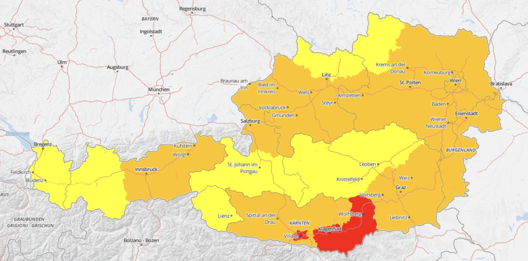
Heat is now the deadliest natural hazard in Austria. In Austria, urban areas and conurbations in particular are repeatedly and severely affected. The number of hot days – days on which the air temperature rises above 30 degrees Celsius – is steadily increasing. In 2024, more than 50 hot days were recorded in the centre of Vienna (Innere Stadt district) for the first time.
GeoSphere Austria compiles the data for the national heat protection plan and the heat protection regulation, which set out measures to be taken in the event of very high temperatures to protect the population living in Austria from the health consequences of the heat, and is thus the linchpin of the heat warning system in Austria.
The National Heat Protection Plan, in its current version dated 2026 and published by the Federal Ministry of Labour, Social Affairs, Health, Care and Consumer Protection (BMASGPK), was drawn up in cooperation with the federal states and GeoSphere Austria, and sets out the measures to be taken in the event of extremely high temperatures and heatwaves.
The plan is based on legal provisions designed to protect workers from hazards such as heat, including the Heat Protection Ordinance (Hitze-V), which has been in force since 1 January 2026 and focuses primarily on outdoor work.
Advisory services for civil protection
As part of AMAS (Austrian Multi-Hazard Impact-based Advice Service), a key component of the State Civil Protection Service (SKKM), the impacts of extreme heatwaves are recorded, categorised and assessed holistically using an interdisciplinary approach. Heat events are often prolonged and affect public health, the risk of forest and field fires, air quality, water management, infrastructure, food supplies and energy supplies. AMAS ensures a comprehensive assessment and also includes long-term forecasts for the coming weeks.
Heat warnings
GeoSphere Austria provides the information needed to protect the public from potential heat-related risks and other weather hazards via a web-based, four-tier warning system. The warning levels (Yellow, Orange, Red) are based not only on meteorological measurements but also take into account factors that influence the potential risk, such as the season, air pollutants, vegetation or regional pre-existing conditions. In addition, recommendations are provided for the protection of people and property. Weather warnings in border regions are coordinated internationally and published on Meteoalarm alongside warnings from other European meteorological services. From warning level 2 (Yellow) in the application onwards, measures to protect workers are required.
Warning level
Meaning / Threshold
Level 1: No active warning (green)
No heat stress is currently expected
Threshold: perceived temperature < 30 °C
Level 2: Caution (yellow)
A slightly increased risk of heat stress is expected
Threshold: perceived temperature ≥ 30 °C
Level 3: Warning (orange)
An increased risk of heat stress is expected
Threshold: perceived temperature ≥ 35 °C
Level 4: Danger (red)
Severe heat stress is expected
Threshold for perceived temperature: ≥ 40 °C
Heat warnings are issued on the basis of the forecast perceived temperature. In addition to air temperature, factors such as humidity, wind and solar radiation are also taken into account. The warnings are based on forecasts from high-resolution weather models and are issued when specified thresholds are exceeded over a period of several days. Factors such as night-time cooling and the time of year are also taken into account in the assessment. As the effects of heat can vary depending on the situation, potential health risks are also factored in when determining the warning levels. The warnings are published at district level and are supplemented by information on possible effects and recommendations to protect the public.
Heat refers to a condition of unusually high air temperatures that is perceived as uncomfortable. For humans, however, heat is actually more than just the temperature: humidity, the (lack of) wind and strong sunlight can also have a significant impact on how hot we feel.
What is the Austrian heat record?
The Austrian heat record stands at 41.2 °C and was recorded on 5 August 2026 at the Bad Deutsch Altenburg weather station (Lower Austria).
What are hot days?
Hot days are days on which the maximum temperature exceeds 30 °C.
What are extreme hot days?
Extreme hot days are days on which the maximum temperature exceeds 35 °C.
What are tropical nights?
Tropical nights are nights on which the minimum temperature does not fall below 20 °C.
What is a heatwave?
There is no standard definition of the term ‘heatwave’, as heat is perceived differently depending on the region. In Central Europe, a heatwave is often defined as a period of three consecutive days, each with a maximum temperature of 30 °C or above. An even more precise definition is provided by the so-called ‘Kysely days’: the heatwave lasts as long as the average maximum temperature over the entire period remains above 30 °C and the maximum temperature on no day falls below 25 °C. The days comprising such a heatwave are also referred to as ‘Kysely days’.
Why are cities more severely affected by heat?
In cities, the so-called urban heat island effect comes into play. The urban heat island, sometimes also referred to as a heat island, is a term from urban climatology and describes the temperature difference between the city – which is usually warmer – and the cooler surrounding areas. This discrepancy is particularly pronounced at night. There are many reasons for this effect:
Flächen aus Materialien wie Asphalt, Beton, Metall oder Glas speichern mehr Wärme. Das führt zu einer Aufheizung und Häufung von Tropennächten.
Es gibt in Ballungsräumen weniger schattenspendende Bäume und Grünflächen und somit kann auch die Verdunstung nicht zur Abkühlung beitragen. Die versiegelten Flächen speichern zudem keine Feuchtigkeit, wie es natürliche Böden machen.
Es kommt außerdem zur sogenannten anthropogenen Wärmefreisetzung, etwa durch Industrie, Verkehr oder auch Hausbrand.
Auch die Beeinträchtigung der Luftzirkulation durch Hochhäuser kann dazu beitragen. Durch die Verbauung kann die Luft weniger gut zirkulieren und kühlender Wind nicht für ausreichend Belüftung sorgen
What are the health effects of the heat?
The health effects of heat stress on humans include: dehydration, weakness, heart problems, headaches, nausea, dizziness, exhaustion, heatstroke, sunstroke and the exacerbation of pre-existing conditions.
Who is affected?
Everyone is affected by increased heat stress!
Those particularly at risk include older people, babies and young children, people with health conditions, pregnant and breastfeeding women, people with substance use disorders, outdoor workers, athletes, homeless people, and those who are not accustomed to high temperatures, live in difficult housing conditions or in isolation, and do not understand the local language.
What are the long-term consequences of rising temperatures for the Earth?
The consequences of increased heat on Earth include: drought leading to crop failures, falling groundwater levels, drinking water shortages, the risk of wildfires, damage to infrastructure (roads, railways, power lines), glacier melt, and an increase in thunderstorms accompanied by heavy rainfall and mudslides.
Measures to combat the heat?
Immediate measures are being taken through the application of the Heat Protection Ordinance (protection of workers carrying out outdoor work), as well as the implementation of the National Heat Protection Plan and the respective plans at federal state and local authority levels.